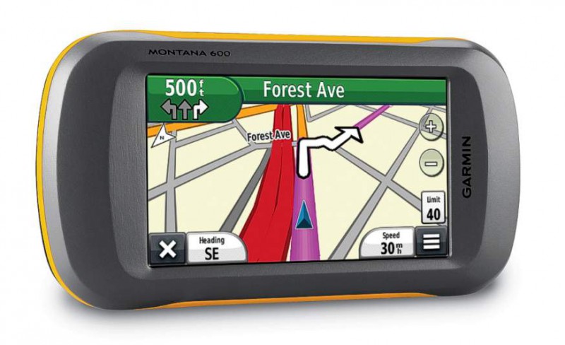
The Garmin Montana 600 GPS unit is a new and innovative handheld GPS that can be used for a whole range of activities, from walking and trekking in the mountains, to use as a SatNav car unit. With a large and easy to see 4” sunlight-readable touchscreen, the Montana offers crystal clear resolution allowing you to orientate yourself simply and quickly. Ideal for outdoor use and use when on a boat, the Montana is durable and waterproof so can withstand pretty much everything you throw at it.
With a definite outdoor slant, the Garmin Montana 600 has a range of features that make it handy to use when walking or trekking, such as: a 3-axis tilt-compensated compass which shows your heading even when you’re standing still; barometric altimeter which tracks changes in pressure to pinpoint your precise altitude, as well as being able to use the Barometer to plot barometric pressure changes which can offer you advanced warning of changing weather conditions.
With your new Garmin Montana GPS, you can share waypoints, tracks, routes and geocaches wirelessly with other compatible Garmin GPS users, allowing your friends to get involved with what you are doing and see what you’re up to.
Montana 600 features a one-of-a-kind dual battery system. You’ll have the option of using the rechargeable lithium-ion pack or traditional AA alkaline batteries – whichever suits you best.
As Geocaching becomes a more popular and successful pasttime, the Montana 600 has been fitted with a facility to support geocaching GPX files so that you can download geocaches and details straight to your unit. Simply upload the GPX file to your unit and start hunting for caches.
If you’re looking for one GPS unit that will do everything, from navigating you round London to showing you the way up Skiddaw or seeking out a hidden Geocache under a rock in Herefordshire then this is the gadget for you.
| GARMIN MONTANA 600 SPECIFICATIONS | |
| Unit dimensions, WxHxD: | 2.9″ x 5.7″ x 1.4″ (7.48 x 14.42 x 3.64 cm) |
| Display size, WxH: | 2″W x 3.5″H (5.06 x 8.93 cm); 4″ diag (10.2 cm) |
| Display resolution, WxH: | 272 x 480 pixels |
| Display type: | bright, transflective 65k color TFT, dual-orientation touchscreen; sunlight readable |
| Weight: | 10.2 oz (289 g) with included lithium-ion battery pack; 11.7 oz (333 g) with 3 AA batteries (not included) |
| Battery: | Rechargeable lithium-ion (included) or 3 AA batteries (not included); NiMH or Lithium recommended |
| Battery life: | up to 16 hours (lithium-ion); up to 22 hours (AA batteries) |
| Waterproof: | yes (IPX7) |
| Floats: | no |
| High-sensitivity receiver: | yes |
| Interface: | high-speed USB and NMEA 0183 compatible |
| GARMIN MONTANA 600 MAPS AND MEMORY | |
| Basemap: | yes |
| Ability to add maps: | yes |
| Built-in memory: | 3400 MB |
| Accepts data cards: | microSD™ card (not included) |
| Waypoints/favorites/locations: | 2000 |
| Routes: | 200 |
| Track log: | 10,000 points, 200 saved tracks |
| GARMIN MONTANA 600 FEATURES | |
| Automatic routing (turn by turn routing on roads): | yes (with optional mapping for detailed roads) |
| Electronic compass: | yes (tilt-compensated, 3-axis) |
| Touchscreen: | yes |
| Barometric altimeter: | yes |
| Camera: | no |
| Geocaching-friendly: | yes (paperless) |
| Custom maps compatible: | yes |
| Photo navigation (navigate to geotagged photos): | yes |
| Outdoor GPS games: | no |
| Hunt/fish calendar: | yes |
| Sun and moon information: | yes |
| Tide tables: | yes |
| Area calculation: | yes |
| Custom POIs (ability to add additional points of interest): | yes |
| Unit-to-unit transfer (shares data wirelessly with similar units): | yes |
| Picture viewer: | yes |
| Garmin Connect™ compatible (online community where you analyze, categorize and share data): | yes |
Source: https://www.garmin.com/